Walk 3. - Maiden Newton, Dorset, England
Distance : approximately 9 miles
How to get to the start : Approach from the A 37 (Dorchester to Yeovil), signed Maiden Newton.
O.S. Map: Explorer 117 or Landranger 194
This is a circular walk, mainly across field or on lanes and tracks, but with a few quiet roads.
The walk begins and ends at St Mary's Church, Maiden Newton. There is street car parking available.
1. From the church walk along Church Road, past the war memorial and the Post Office. At the junction with the main road, turn right. Continue along this road and just after the bakers' shop enter a field on the left by going over a small bridge. After crossing the bridge turn right and follow the river to a kissing gate. Go through the gate and turn right to another kissing gate in the corner. This brings you out onto a road where you turn right. Go straight over at the crossroads (sp Wynford Eagle) and continue along this road for about 2km. You pass a phone box and shortly after this there are some farm buildings on the left.
NOTE There is now a choice of routes. Stage 2a has less road walking but takes you through a pig farm. . To avoid this, use stage 2b, which involves slightly more quiet country road walking. Either stage will lead to stage 3.
2a. Continue straight ahead, past the farm buildings on the left and at the top of the hill go through a gate on the left onto a wide track (sp Jubilee Trail). Go up the hill, through another gate following the track. Where the track turns left, continue straight ahead (keeping the hedge to your left). In the corner turn left through a gate and now keep the fence to your right. Just before the barn go through a gate on your right and turn left to go past the barn to the top right hand corner of the field (still signed Jubilee Trail). Continue ahead with the fence on your right and turn right through a gate at the end of the field. Keep the pigs to your right and the fence to your left and head for the farm buildings . You come out at a road where you turn right.
2b Between the farm buildings (opposite the road to Askerswell) turn on to a footpath to the left (sp Greenford Lane). Go up the wide track, turning right at the chalk pit and through two gates. Keep the telegraph poles and then the hedge to your left. Go past a building to your right and continue until you reach a gate. Go through this gate, then turn left to come out on to the road opposite farm buildings. Turn right and walk along the road for about 1.5km to Compton Barn pig farm on the right.
3. Continue along the road past the pig farm (on your right) and ignore road turning to the left. At the cross roads go straight ahead (sp Kingston Russell Farm) and take a footpath to the left about 100m after the telegraph wires. Cross the field aiming for Hardye's monument on the horizon (diagonally right) On a clear day you can see the sea further to the right. Go through a metal gate onto an overgrown lane between two hedges. At the end of this lane go through another metal gate.
4. Directly under the power lines turn left through a gate (sp Macmillan Way). Keep the hedge to your left and go down and up to a gate. Cross the next field, keeping the hedge on your left and go through a gate leading on to the road. Turn left along the road and then in 50m turn right over a double stile. Keep to the right hand edge of the field . Just before a gate turn right (there is a Macmillan Way sign on a tree stump) and follow a pleasant shaded green lane.
5. Go through a gate and follow a lane downhill to the left. You come out at Compton Valence church. Turn right and walk along the road passing village notice board and a phone box. You very soon turn left and go through Lower Dairy and past Green Pastures Barn. Go through a gate and follow the track between fences.
6. At a collection of gates take the third gate from the left (Macmillan route) and go along the side of the hill to a solitary tree. At this tree turn left and aim for the gate. Turn right along an uphill track (be careful not to fall down badger holes). Go through a gate in the top corner and follow the field edge to two wooden signs. Do a staggered straight ahead (sp Notton) along the left edge of a field. Go through two gates in a dip and follow the path (sp Notton) uphill and then past some houses.
7. Follow the route sign posted Notton (we leave the Macmillan way here) over a cattle grid, down a steep track and over another cattle grid. After a gate keep straight on and then follow the track to the left along a wall (sp Cruxton in the wall). Continue along the track going through 4 gates (still following signs to Cruxton). Where the Macmillan way rejoins from the left continue straight ahead for about 25m before turning right through a gate. Head for the houses and the road.
8. Go along the road ignoring the footpath on the right (sp Maiden Newton) but after a further 150m take the next footpath on the right (sp Lower Frome Vauchurch) . Go diagonally through the gap in the hedge and then through the gap in the next hedge. Turn left and through a gate to join the road. Go straight ahead at the junction by Frome Vauchurch church. Go over the bridge and out on to the main road.
9. Turn left and go past the Chalk and Cheese public house and turn right in front of the Lifestyle corner shop. Go past the Post Office, bear left at the war memorial and continue along Church Road to find St Mary's Church again.
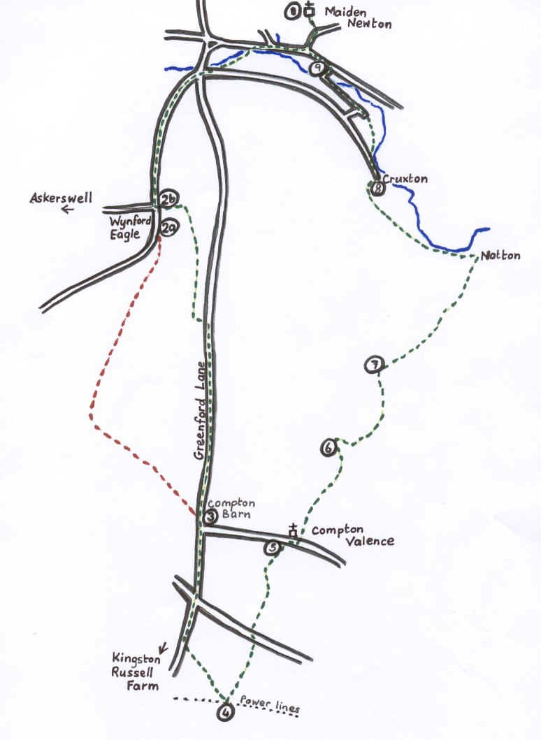
MAP
|
Back to walking