Distance: 5 - 6 miles
Explorer map 117, Landranger map 194
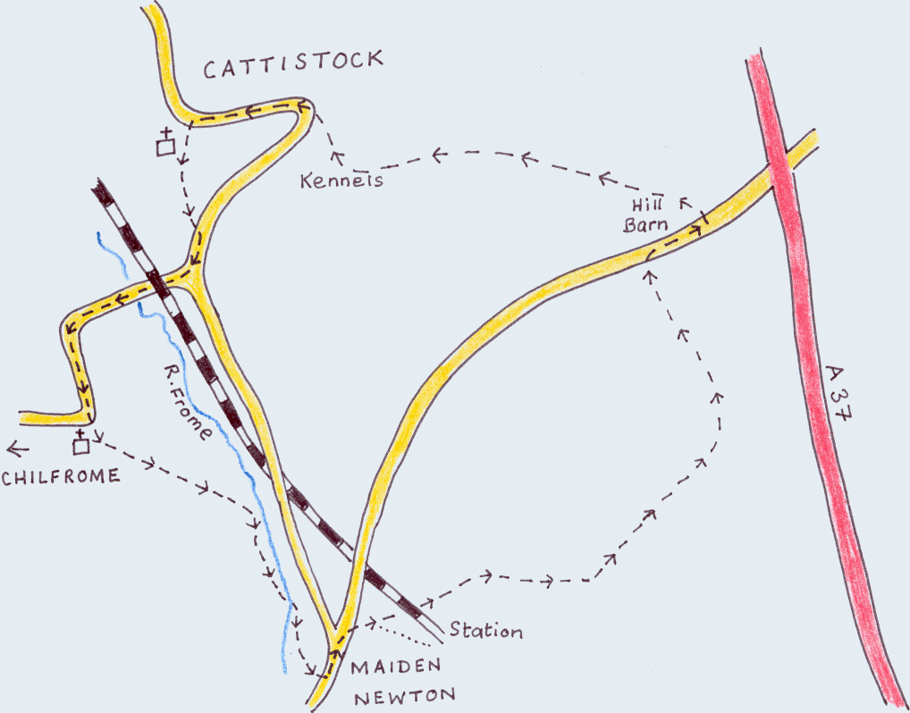
- Starting at the square in the centre of Cattistock village, head through the churchyard, keeping to the left of the church. Leave the churchyard through a small gate and go along a narrow lane at the back of some bungalows. After passing through a kissing gate, go along a path between 2 fields and through a second kissing gate. Turn immediately right (following the Macmillan footpath sign) and, after passing the cricket ground, turn right (signed Chilfrome). Continue along this road and under the railway-bridge. The road bends sharply left, but where it turns right, go between a thatched cottage ("Greenings") and Chilfrome church.
- Pass through a gate and across the field to another gate. Cross this field to a stile in the opposite hedge. Go over the stile and turn immediately left to head for a second stile. Go over this stile and keep to the left of the field. Turn right and walk along the riverbank, then under a railway bridge and through a gate.
- Turn left, then right along the right bank of the river. Cross the river at a wooden bridge, following the Wessex Ridgeway sign (you leave the Macmillan route at this point). Turn right and follow the left bank of the river for a while.
- The path leads you into a field. Cross this field and head for the church. At the church wall turn left and cross a stile. Turn immediately right and on to the road, which leads into the village of Maiden Newton (post office, grocery shop, newsagent's, baker's, pub!)
- At the war memorial turn left along Station road. At the crossroads turn right (signed 'Station') and continue straight (ignoring the Station turning to the right) under the railway bridge. Keep on the long uphill track and, shortly before the path bears to the right, turn left through a gate (still following the Wessex Ridgeway signs). Keep to the track with the fence on your right. At the end of the fence keep straight and go through a metal gate.
- Follow the track round to the right with buildings on your left. Immediately before the last building turn left, then left again through a gate and immediately right to walk along the top edge of the field with the hedge on the right. Pass through a gate and continue along the top of the next field. Immediately before the next gate turn left and follow the grassy track, keeping the hedge on your right. Go through a gate on to the road and turn right.
- Continue on the road for about 200 yards, then turn left through a metal gate (footpath sign - Cattistock). Angle left and head towards the distinctive radio masts of Rampisham on the horizon. Go through a gate to the right of the derelict farm buildings. Walk along the top of the field, keeping the hedge on your left. The path bears slightly right and through a gate in the hedge. From here the path descends and finally comes out on to Kennel Lane. Turn right and down to a grassy roundabout, where you continue along the road into the village. You will pass the Fox & Hounds on your right and shortly afterwards you should find yourself back at Cattistock church, where you started the walk.